A major railway station, a Metro station and a national highway (Peenya Road) are all located close to each other in the Yeshwanthpur suburbs. But these transport modes are not well-integrated, causing major hassles in using public transport here.
2.3 km from old railway station to Metro
The map below shows the distance from the old entrance of the railway station (marked YPR (OLD)), where Platform 1 is located, to the Metro station. This roundabout stretch is about 2.3 km long.
The distance from the new entrance (YPR (NEW)), where Platform 8 is located, to the Metro station is shorter. But the lack of a dedicated path between these two makes it difficult for commuters, especially those with luggage, to switch from Metro to railways, and vice versa.
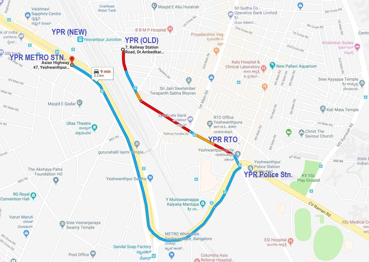
The distance from Yeshwanthpur old railway station to Yeshwanthpur Metro station is about 2.3 km by road. Image: Rajkumar Dugar
Not just railway users, thousands of others too have to take the roundabout route around the YPR (OLD) entrance to the Metro/NH side everyday. This area is a hub of commercial activity and a busy route for daily commute.
Around YPR (OLD) is a densely-populated mixed residential and commercial area as well as an RTO office. Whereas the Metro/NH side is a highly commercialised area with the APMC (Agricultural Produce Market Committee) Yard, major offices, hospitals, hotels and residential apartments. Since non-rail users can’t cross over the railway property, they are forced to take the 2.3-km route between these two points.
Cost of travel by auto or cab along this route is high, on account of the distance as well as huge traffic congestion. Thousands of people commuting by this road everyday adds to traffic congestion and pollution while also resulting in massive loss of man-hours.
Poor people who cannot afford the transit cost are often forced to walk along this route. This may take about half an hour, one way. We must remember that this entire stretch is a high-density traffic corridor with thousands of vehicles plying every hour, round the clock.
But a 200 m foot-over-bridge (FOB) will eliminate the need for the roundabout trip. Here’s how.
An FOB to connect railway, Metro and bus stop
A new 200m foot over bridge (FOB) across the old railway station entrance and the NH, with suitable features, will obviate the need to use the road. The FOB should be located outside the railway station, so that non-rail users can access it.
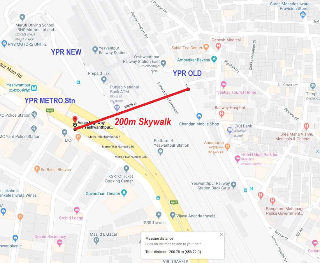
A foot-over-bridge connecting the old railway station and the Metro station will cut down travel distance from 2.3 km to 200 m. It will encourage the use of Metro too. Image: Rajkumar Dugar
The bridge would help pedestrians, train and Metro commuters, and also bus users. The bus stop on NH is just about 100 m away from the Metro station; hence the FOB would offer easy access to it. In sum, the FOB would integrate multiple modes of transport – walking, railway, bus and Metro – and reduce traffic congestion and pollution in the area.
Bengalureans have been requesting this FOB for quite some time, including on social media. Recently, the Divisional Railway Manager for Bengaluru tweeted in response to a citizen’s request for the FOB, that an ”MoU for the same is finalised between Railways and BMRCL. Work will shortly be taken up by BMRCL.”
Speaking to Citizen Matters, Parvesh Kumar, Senior Divisional Engineer (Coordination), SWR, said that the MoU would be finalised in a few days. However, the project needs to be sanctioned in the budget next year, and only then would further details be available, he said.
Since the project is in the initial stages, BMRCL and SWR could consider the following suggestions for the FOB that two citizen groups – Praja RAAG and Citizens for Citizens – have been proposing.
Features
- Length of FOB: 200m
- Height: About 15m
- Width: About 10m
- Suitable escalator and staircase at both ends
- No fee to be paid by users
- Public toilet – at least on one end of the FOB, with signages
- Completely covered, with ventilation
- Adequate lighting for night usage
- No vendors allowed
- End-to-end security with CCTV cameras etc
- FOB to be connected to the existing FOB inside the railway station, so that commuters can walk into the railway platforms directly. Railways can also set up a counter to issue platform tickets here, so that those accompanying the commuters too can access the platforms.
Benefits
- Drastic reduction in distance – 2300 m to 200 m
- Easily walkable for most people
- Will result in huge savings in time, fuel and cost. Will reduce congestion and pollution
- Will be especially helpful to the thousands of people who live and work along the old railway station and NH
- Will help thousands of people from the old Yeshwanthpur station side use the Metro
SWR and BMRCL should clear the project on priority, and fast-track implementation. If the two agencies are not able to implement this project on highest priority, we appeal to the people’s representatives – local MLA, Deputy Chief Minister C M Ashwathnarayana, CM, MOS Railways and others – to intervene and ensure the needful.
[Ekta Sawant contributed to this article]
similarly, an underpass below, the ypr rail lines connecting JP park/mattikere area to Ypr should reduce the traffic burden on ORR/ goragunte palya.
You mean Mohankumar road connecting Tumkur road right??
Thanks Rajkumar D. Very well written and very much needed one as of yesterday. I have walked this stretch several times cursing. In some places footpath is not even one or two feet and are forced to get down to road with heavy traffic and pollution