On 30th August, a resident of Rainbow Drive, a layout on Sarjapur Road, passed away as he could not get to a hospital in time. His community had been flooded and its residents marooned for hours during which even tractors could not reach them. On 5th September after the heavy overnight rains of up to 90 mm, residents of this area and the larger Sarjapur Road-Outer Ring Road area continue to suffer, with large sections of even main roads inundated.
Rainbow Drive is one of the parts of the city that has had far too many trysts with flooding. Even as recently as August 3rd, people had to use tractors to get out of their homes to reach offices and schools. The rain recorded in Bellandur that day was a mere 46.5 mm.
But why are areas like Rainbow Drive so vulnerable to floods?
Why it floods in Rainbow Drive
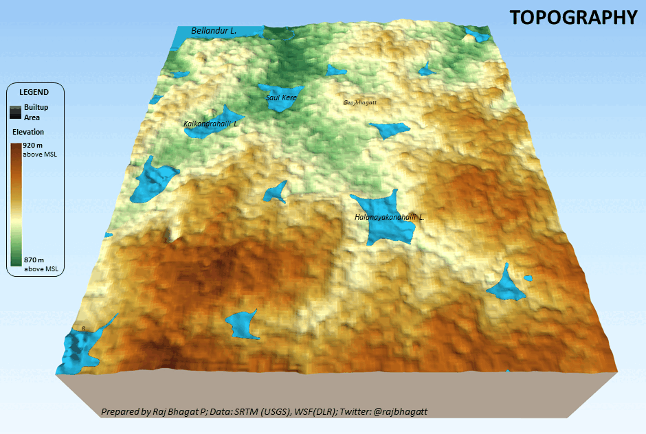
KP Singh, a resident of Rainbow Drive explains the context. The layout is spread over 35 acres, developed some 25 years ago on what were once paddy fields. This area, as one can see on the elevation map, is in a valley area, connecting the lakes of Halanayakanahalli and Junnasandra downstream to Saul Kere.
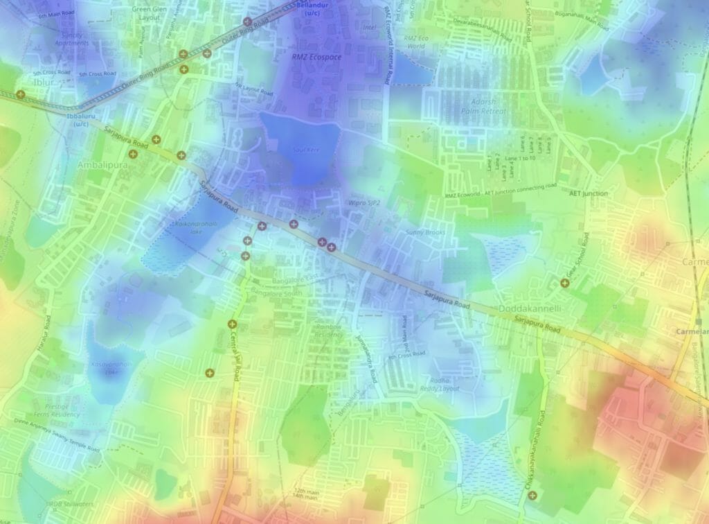
The kaluve carrying the overflow from Junnasandra ends at Rainbow Drive. In addition, the level of the Sarjapur Main Road has increased by over 3 feet, says KP Singh, while the layout is at the original valley level. “This means the water reaching the Rainbow Drive exit gate is not flowing fast enough towards Saul Kere. As of now, Sarjapur Road stormwater drain is not wide enough to carry the rainwater accumulating at the RBD gate.” In the same way, the valley connecting Saul Kere to Bellandur lies on the ORR-Ecospace area, where too it was flooded.
Water expert S Vishwanath explains the original lake system was designed with kodi kaluves or waste weir overflow channels, to handle overflow from those lakes to Saul Kere, from which in turn water overflowed to the Bellandur-Varthur waste weir channel. (Raja kaluves actually refer to the channels used for irrigating the command area.)
Vishwanath says, “we have ignored the kodi kaluves.” Each lake typically had two waste weirs to let the overflow water move downstream. Most of these channels are now defunct, except in the larger lakes like Yelahanka, Bellandur and Jakkur which continue to have two waste weirs but only one waste weir channel.
How “development” leads to flooding
Before these areas got built up, water would also flow in “sheets” into the lakes and out of the lakes after heavy rains, not just restricted into channels. KP Singh remembers seeing the water just flowing over Sarjapur Road till a decade ago. But now these lakes are completely surrounded by ‘bunds’ which prevent sheet flow and cause water logging on their sides.
With heavy rainfall, the volume of water or runoff is too high to be limited to flowing in these narrow and sometimes missing kaluves. Vishwanath says, “Given that the catchment areas are now paved with concrete, there is no percolation into the ground, and the kodi kaluves have to deal with five times more water!”
The root causes of flooding
Researchers at Gubbi Labs found how a mere 8% of the ‘Headwater Streams’, the uppermost streams in a river network, were open, a number of others were either covered or altered; a whopping 60% have either disappeared or were untraceable. About 27% of the second-order streams were untraceable. First-order and second-order streams play a critical role by trapping floodwaters, recharging groundwater and also carrying water to the downstream rivers.
Read more: Floods in Bengaluru: Engineered, legally!
Malini Ranganathan, an academic and researcher who has studied Bengaluru’s heightened flood risk has documented how agricultural land and commons including rivulets, marshes, and drains have been filled in and parcelled by developers into sale-able properties. Instances of encroachment and land grabbing are not uncommon. All this resulted in obstructing the flow of stormwater and the percolation of groundwater, eventually leading to the current situation.
Read more: Why Bengaluru is not immune to floods: It’s all about land (and money)
The Comptroller and Auditor General observed in a report that the kaluves were not directly connected to lakes; rather their water was channeled into diversion canals built adjacent to the lake as they were carrying sewage. This led to overflows and flash floods.
Even the city’s built drainage system has been badly mismanaged by the city corporation BBMP’s Stormwater Drain (SWD) department.
Read more: 50% stormwater drains lost: Bengaluru’s flooding is no surprise
It is not just in the building of infrastructure and the day to day maintenance, there are issues right at the planning level and in the quality of data.
As the CAG report pointed out, Bengaluru still doesn’t have a complete map or database of its drainage network, which is critical for city planning. In any case, while sanctioning the building plans of constructions near stormwater drains.
Read more: BBMP never had the habit of checking any village maps or master plans
Raj Bhagat Palaniswamy, a geo analytics expert and Senior Programme Manager at the World Resources Institute points out the need for data: “We need a lot more data – topographical data, we need data on the stormwater drains, we need data on which areas are flooding.” A good understanding of topography and valley systems is a critical input to the master plan.
What is the solution?
The flooding of Rainbow Drive is ironic given that it is a pioneer in rainwater harvesting and waste water treatment and one of the few neighbourhoods in Bengaluru’s peripheries that is completely water sustainable.
Read more: How a Sarjapura Road layout became free of water troubles
But their current situation is the cumulative result of decades of uninformed decision making at multiple levels – from the state to real estate developers to the individual property owners in the entire area.
Priya Ramasubban, a lake activist who has worked on many of the lakes in the neighbourhood, says one can’t just stop with blaming the government, “Residents attach a lot of importance to their property value and immediate amenities over long-term needs. Active citizens know which properties have encroached low lands or watershed/valley areas but they don’t dare challenge the systems lest they find themselves in the crosshairs of neighbours who don’t like them, or to have lost a bit of their property value.”
A sustainable solution requires all parties to acknowledge these issues and look at the entire area holistically. Priya says, “Without collective action and a willingness to sacrifice, we won’t get anywhere. So we have to decide, do we want to just suffer a few days of floods and then move on or work to bring lasting change to our neighbourhood that could be painful to make and could result in a lot of work.”
What can be done right now?
Two weeks ago, Mahadevapura Special Commissioner said BBMP would survey the stormwater drains in Rainbow Drive as there were encroachments and properties built on the kaluves. But a piecemeal approach is problematic when the entire lake network and the land topography needs to be analysed, and the drainage network through SWDs and kaluves need to be relooked at from an environmental and equity perspective.
KP Singh says there are some immediate action items to prevent their layout from getting flooded in the short term: First, the authorities can open Halanayakanahalli lake sluice gates whenever necessary. BBMP must take up construction of stormwater drains along Junnasandra Road as well as the western boundary of Rainbow Drive to take the water to the culvert. The Halanayakanahalli lake’s overflow from the east side of Rainbow Drive should have a proper channel towards the culvert too. Finally, it is essential to ensure desilting of the Junnasandra and Halanayakanahalli lakes, in the summer.
Flooding now ubiquitous in the city
In any case, such challenges are not just Rainbow Drive’s alone.
A recent study by the Karnataka State Natural Disaster Monitoring Centre (KSNDMC) has found that Bengaluru’s rainfall patterns have been changing and it is an indicator of climate change. Data from IMD and KSNDMC also show that the annual rainfall has been increasing steadily over the past few decades.
Vishwanath S says, “Bengaluru will need to rework its building design and stormwater design codes to deal with the increased rainfall, and also intensity of rainfall. We need to design for short bursts of 180 mm per hour intensity and for 200 mm per day rainfall. Roof slopes, rainwater pipes, storage and recharge structures and stormwater drains will all need to cater to this new regime of rainfall. We also need to improve our predictive powers and models of rainfall events.”
What you say is hundred percent right. A piece meal approach to town planning has led us to such a situation. We have invested in roads, underpasses, flyovers with very little provision for storm water drainage. In fact it starts from our home construction. all buildings have the surrounding garden mostly covered with tiles or concrete. Whenever rain falls, it cannot percolate gradually into the soil. Instead it accumulates. Likewise all our public facilities. The accumulated water tries to flow from high to low, as in Rainbow Drive. Or it flows through the man made paths of roads as temporary rivulets. So today the CM has to talk about emergency SWD, without a scientific or engineering plan for this infrastructure is being built. Our smart city projects have not taken water drainage into account. Water accumulation leads to deterioration of infrastructure, so no one should be surprised about potholes. We have not built an infrastructure for the present population and are suffering its consequences. needless to say, this problem will be forgotten till the next storm!
Why aren’t buildings built on water channels in Rainbow Drive being demolished
As a exHAL retired engineer I have seen sudden developments during early time of 2000 millennium ,when ORR was planned and executed, 100 s of acres wet land on the either sides land was quickly converted and made land parcels without ensuring drainage systems and strom water storages.Big IT giants and properties developers cornered these land and built Apartment and office spaces.
It is not necessary that reasercher should give the opinion
It is a well known fact that the area inundated in water are low level area or lakes or feeders streams to the cauvery belt
All these areas and lakes and streams and water ways have been fill with debris and converted into concrete jungle with aid of greedy Government officials who have sanctioned building plans
The citizens in their hunger for property were greedy enough to buy these properties in the waterway areas
The prestige, embassy, salarpuria, eco space erc are more greedier real estate Empire who are root cause for this calamity
As I remember these areas were filled with waterways and water bodies in 1965 to 1985
Challaghatta lake was my office route to ASTE IN 1980 TO 1985 WHEREIN IT WAS A BIG LAKE ADJOINING THE ROAD NOW IT FULL OF DEBRIS AND TREES WITH A HUTMENT COLONY WITH A AMBEDKAR HOARDING
NO POLITICIAN IS DARE TO GET THAT REINSTATED
Bangalore or any city requires planned development. The rate at which the cities are growing in terms of population is far exceeding development. Best way is to decongest cities and develop tier 2 cities/ towns. In this way it will become sustainable.