I have lived on the Outer Ring Road (ORR) for 15 years now. It has shaped my life to such an extent that it is one of the narratives I use to recount my time in the city. Orienting myself with the everyday changes on this road has shed light on my place as a resident, commuter, voter and more importantly as a citizen – a part of a larger whole.
With the announcement of the environmental clearance application for the Peripheral Ring Road (PRR), it seemed prudent to look back on what the journey has been like on the Outer Ring Road, quite literally.
The promise of the road
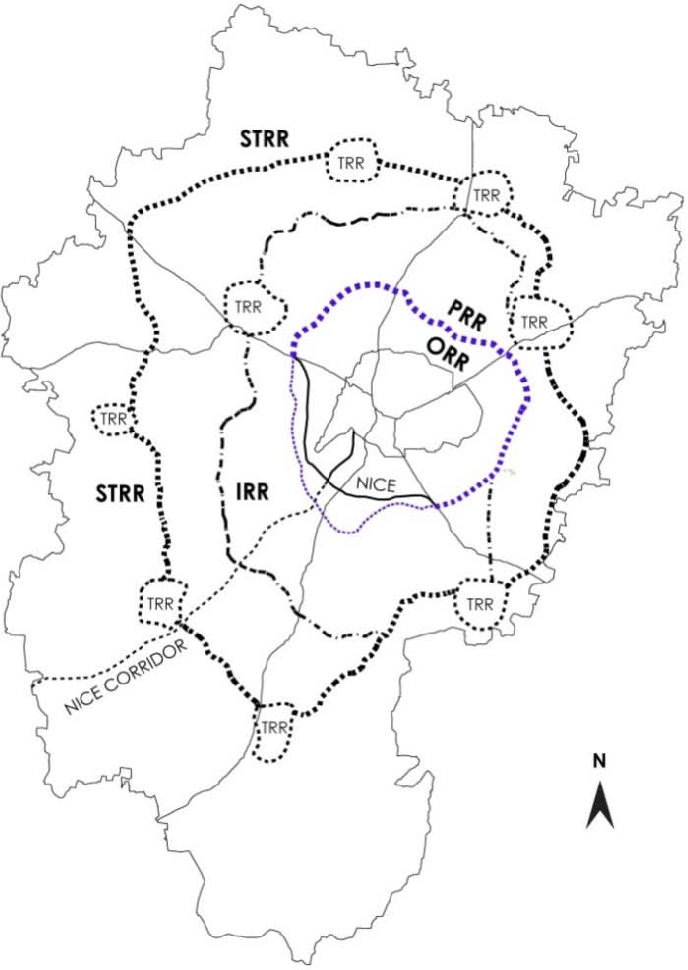
The Outer Ring Road is a 62 kilometre-long road that runs around what used to be the extent of the city in the 1980s and 1990s. Bengaluru’s high visibility as the capital of India’s Information Technology sector conceived the city as a space for an unimpeded flow of commodities, people, and information (Janaki Nair, 2005). It was planned and constructed by the Bengaluru Development Authority (BDA) to displace heavy vehicles from inner city roads, but it is now synonymous with the location of tech parks, commercial establishments, and residential layouts. It was opened in phases from 1996 to 2002.
With the growth of the city from a population of 48,39,162 inhabitants in 1991 to 1,31,93,000 in 2022, the Outer Ring Road is glaringly beyond its use capacity. My apartment would not have been located where it is right now had the Outer Ring Road not been there.
The dream of this rapid transit road ironically hiked the real estate development, abetting increased vehicular traffic. The more the road adjacencies developed, the more use the road saw, not just in terms of vehicular movement, but in commercial establishments, on-road parking, street vending, and encroachments. In 2015, a study showed that Outer Ring Road, which was built to ease traffic congestion in Bengaluru, had the biggest traffic jams in the city.
For this reason, the BDA and BMRDA had planned three more ring roads, which are either incomplete or yet to be implemented. The first of these is the Peripheral Ring Road (PRR), which was announced in 2005. The construction of the PRR is impeded by land acquisition hurdles, associated cost overruns, and stakeholder dissent.
However, in November 2022, BDA applied for environmental clearance on the project, more than 15 years after the land acquisition started. It will run a few kilometres beyond the Bengaluru Mysore Infrastructure Corridor. The second and third of these are called the Intermediate Ring Road (IRR) and the Satellite Towns Ring Road (STRR), respectively.
Read more: “Widening well-developed roads is not development”
Bengaluru received as many as 11 mega-city projects announced in 1997. Flyovers and grade separators have certainly put the gleam back in the eyes of those who dream of corridors of speed. Such projects have also succeeded in keeping at bay any surprising or uncomfortable encounters with the realities of urban poverty and survival.
The initial idea for the Outer Ring Road was exceedingly hopeful. As a child, I remember being in awe of this new road that let us travel from our house in Banashankari 3rd stage to my grandfather’s house in Nandini layout in just 20 minutes. The best part was that there were no signals to wait at. To an eleven-year-old, it held a promise of seamless connectivity within the city. Now, however, with countless grade separators, the absence of trees and footpaths, and continuous high retaining walls, I perceive the same as a threat.
What the road showed me
As we made this trip, every week, these past 15 years, I came to observe all the changes the areas in between went through. Initially, they were just landscapes in the window, large expansive land evolving into retaining walls and service roads. They evoke the political, affective, and material histories that often render these otherwise mundane spaces so controversial.
The road has been referred to by many names. I have known it as the 100 feet ring road (not to be confused with the 100 feet road in Indiranagar), a part of it bore Dr Rajkumar’s name and now it has been renamed after his son, as Dr Puneeth Rajkumar road, despite some conflicts. Every now and then there are demands to rename parts of the road. Since the road connects most of the city, it witnesses protests, processions, and celebrations. I have seen the vibrancy of this, all along the Kanteerava studio stretch because it does indeed bring traffic to a halt.
Read more: Multiple mega-projects meant for Bengaluru yet to take off
Once the Outer Ring Road congestion became an everyday concern, the ‘Sorry for the inconvenience’ barriers were a common sight. BBMP decided to start road widening projects. The first project was in 2010, and houses along the 100 feet Outer Ring Road were served Transfer of development rights (TDR) notices before the widening.
Some of the houses were less than ten years old at the time. A family friend along the road had lamented that this was not accounted for in the approved site sales. Instead of following through on the 1995 Comprehensive Development Plan and strategising and planning the road network accordingly, firefighting was done to resolve increasing traffic.
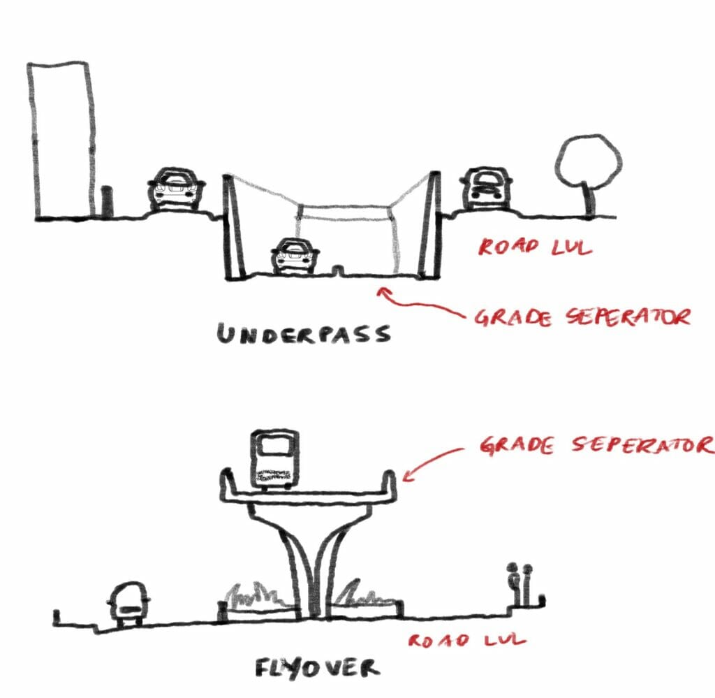
The first solution was road widening and when that didn’t work, the alternative solution was to design signal-free corridors, much like the stretch between Nayandahalli and Rajkumar Samadhi. It continues to be a smooth ride to date, apart from potholes developing and the success of that has put signal-free Outer Ring Road corridors on every government’s actionable plan. The cost of making it signal-free is very high.
The reason is that the municipal and development authorities understand signal-free to mean grade separators, i.e flyovers or underpasses and these are expensive. Grade separators are defined as structures provided at a traffic intersection to separate the streams of traffic crossing each other so that both can flow without interruption. How many different directions the traffic flows is what determines what sort of grade separator is constructed. Even more so, when the execution is poorly planned.
Between Nayandahalli junction and Sarakki signal, in the span of ten years and within a distance of 7 kilometres, there have been four projects with each new development choking the next junction. 2.5 flyovers have been built, and one underpass and one flyover are currently under construction. It seems counterintuitive to build multiple bridges and tear them all down in just a few years to pave way for elevated metro lines.
In 2014, the year I started college, construction on the Kittur Rani Chennamma flyover (Deve Gowda petrol bunk junction) began. This was after the previous government had already laid the foundation stone. It took three painfully dust-ridden years to be completed.
This was due to land acquisition issues between BDA and BBMP, during which sand trucks were perpetually parked in the construction area. Navigating this road was an outright risk since the temporary service road was riddled with potholes and a gaping storm water drain. It was finally inaugurated during my third year of college and the dust settled on the 59 felled trees and land disputes soon after. The inauguration of this choked the subsequent junctions towards JP Nagar. In 2017, it was announced that a second-level flyover will be planned at this junction to further ease the flow and take into consideration all directions of traffic movement.
More than 4.5 lakh vehicles move on the Outer Ring Road and according to the BDA and BBMP officials, the Nayandahalli flyover and the Kittur Rani Chennamma flyover have reduced traffic congestion by about 50 and 65 % respectively. However, the experiences of the outcomes aren’t consistent. The unfortunate situation is that this is still an auto-centric or automobile-focused mentality. Since it is a network, the flyover or underpass ‘fix’ only displaces the problem to a junction downstream and that becomes the new junction to fix.
And so in 2015, during my second year of college, a huge void opened up right in front of my house. The Dr Muthuraj underpass was being constructed at Hosakerehalli junction. The trees disappeared over a week’s time. This was the third-grade separator to be constructed as part of the Nagarothana scheme. I remember the horrors of travelling at the time because apart from bad roads, we had to deal with the re-asphalting of the existing ones before the Karnataka assembly elections in 2018.
The quality of work was not a priority, the mandate seemed to be to finish asphalting it overnight. The roads were great until it rained and the water broke the road open again. Every day as the roads changed, diversions and delays came with it.
[This is the first part in a series of articles on the constant construction work on Outer Ring Road]
Oh !That period while those flyovers and underpasses were constructed, was undoubtedly a nightmarish experience for the commuters who took that road to reach their destination . Their seemingly unending woes spoke volumes about the planning, efficiency (or the lack of it) of the concerned departments.
Can’t wait to read the next part of this well chronicled, factual, interesting article !
The ultimate solution is to shut down the road completely and convert it to an elevated corridor instead of patchworks and more congested signals slowing down the traffic defeating the very purpose of this road which has become the heart of the city now.
I always wonder as to how many comment upon the development projects in the city on their utility, needs . My query is whether BDA/ BBMP does not consult domain experts on such issues or whether the commentators have better wisdom. Quite perplexed. Lack of rapid transit system perhaps negates all these projects. Not sure. Metro ought to
have happened before these projects. Seek experts’ views
A ring road dividing the city instead of connecting. There are no radial roads into the inner city and no proper exits to the suburbs. You need to travel 40 minutes through narrow congested roads to reach it.
How can you have a highway without grade seperators? The narrow underpasses and u turns into them actually block the traffic on the ring road. To save a little money on pillars defeated the purpose of the road itself.
The Inner ring road, Outer Ring road and Peripheral Ring road are a must for a city like Bangalore. These service roads on the ORR should be removed and roads should be widened to accommodate free movement of vehicles as most of the service road are always occupied by parking vehicles like buses & cars The median and drains on the ORR even make things worse as they are constructed between the service road and ORR while it’s occupied by mostly by Hawkers and while it rains the water doesn’t flow into the drains obstructs the flow of water from the main roads and even overflows on to the road.
Town planning commission should also build the underground Metro and Suburban rail and also Flyover asking the ORR keeping in future needs to every growing city.
Request Road transport minister to look into this issue and request to clear the Service road and road median and allow the roads for free movement of traffic.
According to me the best solution for nightmarish traffic woes in Bangalore is TWO UNDERGROUND TUNNELS,ONE FROM ATHIBELE TO KIA AND THE SECOND FROM KENGERI TO HOSAKOTE WITH MANY ENTRY AND EXIT POINTS. THIS IN MY OPINION IS A 100 YEAR SOLUTION. Vehicles going across the City will travel 60KMs per hour without adding to Traffic Jams. I am ready to pay Nominal Toll.