Do you know:
- If you are living in Embassy Golf Links on Inner Ring Road, you are living in an area that is 1300 years old.
- If you are living in Peenya 2nd stage, you are living in an area that is 1300 years old.
- If you are living in Indiranagar you are living in an area that is 800 years old.
- If you are living in Rajajinagar, you are living in an area that is 700 years.
Surprised? But they are all facts.
Srinivagilu, behind Embassy Golf Links, is mentioned in a 750 CE stone inscription; Juganahalli, in Rajajinagar 2nd block, is mentioned in a 1347 CE inscription; Binnamangla, close to Spastic Society, is mentioned in a 1266 CE inscription, Bidarkal in Peenya is mentioned in 750 CE inscription!
The name of a place is an inheritance from the past. The name often triggers many stories about the place, its people’s aspirations, affiliations, victories, trials and tribulations.
Bengaluru, a rapidly growing city, has consumed and continues to consume voraciously hundreds of villages as it expands. Yet many of these “consumed” villages retain their character while adapting and changing with the times.
Read more: Here’s how to check your new ward as per BBMP’s draft delimitation
From villages to municipal wards
From post-independence times Bengaluru has been sub-divided into wards for administrative purposes. In the early decades, one or more of the “consumed” villages would constitute a ward, and lend its name as the ward’s name. Later as more wards were added the names of newer recently built localities were also used for ward names instead of the name of an embedded village. For instance, Defence Colony ward, the Sanjaya Nagar ward, the HRBR Layout ward and the AECS Layout ward, to name a few.
In the recent 2022 ward delimitation proposal, however, while increasing and restructuring ward boundaries, the authorities have named wards after people totally unconnected with that ward. For example, some of these ward names are Ranadheera Kanteerva ward, Vijayanagara Krishnadevaraya ward, and Nalvadi Krishnaraja Wodeyar ward.
This is a tragic decision as it opens a gateway for favouritism and populism with opportunities to promote a particular individual and ignore the historicity of a place. No matter how important a person or their achievements, a place is always greater than any one person. Without clear published guidelines, such random renaming will only result in many “people” names chosen for ward names based on the whims and fancies of a few officials and politicians. With some of these person-based ward names being changed again if the party at the helm changes!
Guiding principles for naming wards
Wards must be named per a simple, published, inviolable guiding principle. The guiding principle should be such that the ward name is –
- Rooted in the ward and
- The name does not discriminate or favour any political party, group or individual.
Most importantly, the name must represent and reflect the glory of the ward.
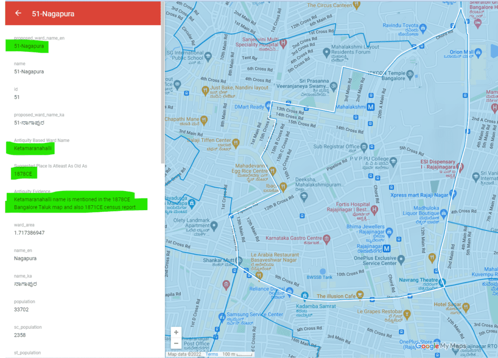
A simple method is to use the name of the oldest village or locality within the ward as the ward name. This was how the ward names were decided in the past.
Based on this simple principle, it is possible to arrive at names for all the 243 proposed wards. Bengaluru is a thriving, global city today, but included within Bengaluru are many vibrant places with a millennium-year heritage. The city must leverage this heritage.
The author and his colleagues from the Mythic Society, Bengaluru Inscriptions 3D Digital Conservation Team have compiled a list of names for each proposed ward and shared it with the authorities as a suggestion. All these names were selected using the following four irrefutable sources:
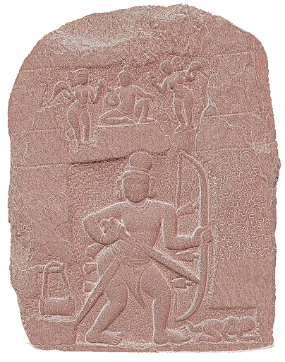
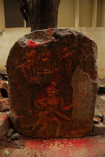
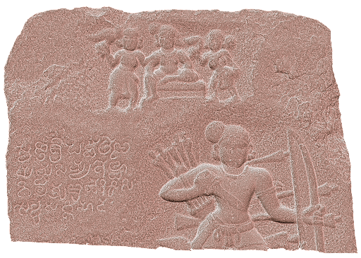
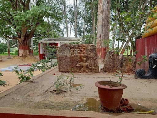
- Ancient stone inscriptions from the 5-16th centuries that are found all over the city. There are some 175 such inscriptions within the boundaries of BBMP. Many inscriptions contain the names of places. These inscriptions have been documented in the magnum opus Epigraphia Carnatica Volume 9, published in 1905 by the Mysore Government. These inscriptions and their text can be seen on this publicly accessible map. Village names featured in an inscription have been used as ward names whenever available.
- A 1878CE map of the Bangalore Taluk of the Bangalore District, Nundydroog Division, photographed at the Government Office Poona by the Survey of India. All prominent villages within the taluk were well captured on the map. Interestingly, BBMP’s present map tallies closely to the taluk boundaries of 1878! This map and its overlay on current satellite imagery can be seen here. Village names featured in the 1878CE map have been used as ward names whenever available.
- 1875-1950CE village revenue maps for the Bengaluru region published by the Commissioner, Survey Settlement & Land Records, Revenue Department, Government of Karnataka. These maps are available online. Village names from these 1905CE revenue maps have been used as ward names whenever available.
- A 1948CE Bangalore Guide Map published by the Survey of India. A physical copy of this map is available at the Mythic Society Library on Nrupatunga Road, Bengaluru. This map shows the prominent localities of Bengaluru of the time. Locality names from this 1948CE map can be used as the ward’s name when available.
From these four sources, it is possible to select, based on strong evidence, a meaningful set of 243 names for each of the wards without having to invent new unrelated ones!
Historical naming patterns
Naming styles for places also follow patterns. Just as terms such as layout (For example, Mahalakshmi Layout and Balaji Layout), phase (like in JP Nagar Phase 1) in a place name are the styles of today, there are other terms that indicate vintage from earlier periods. Some examples of such terms are:
- Sandra as in Jakkasandra, Bommasandra, Channasandra etc indicates these places are likely to be from the 14-16th centuries. The term sandra is derived from Samudra. Lakes built during the time were initially called samudras, but in time the term changed to the colloquial sandra.
- Agrahara as in Agrahara Sampigehalli, Kalena Agrahara, Rupena Agrahara etc indicate that these are likely to be from the 10-16th centuries. Agraharas were originally centres for formal, group-based education. As such education was primarily a Brahmin activity, agraharas were also majorly Brahmin settlements. Over time the word agrahara in some cases has been corrupted to agra, agaram or agram.
- Kaval/Palya as in Jarakbande Kaval, Vyalikaval etc indicate the place to be most likely from the 17-18th centuries. Kaval is a term used for grasslands and palya for small military stations. These terms were very popular during Hyder Ali, Tipu Sultan and British times.
- Pete as in Chikkapete, Balepete indicate the place to be most likely from the 17-18th centuries. Petes were established within the Bengaluru fort and the term pete would be preceded by the vocation or goods sold in that small region within the fort.
Read more: BBMP’s flawed delimitation plan: Why Mahadevapura residents are demanding a separate municipality
The suggested alternate names and details about the proposed wards as provided by BBMP are all shown on this map
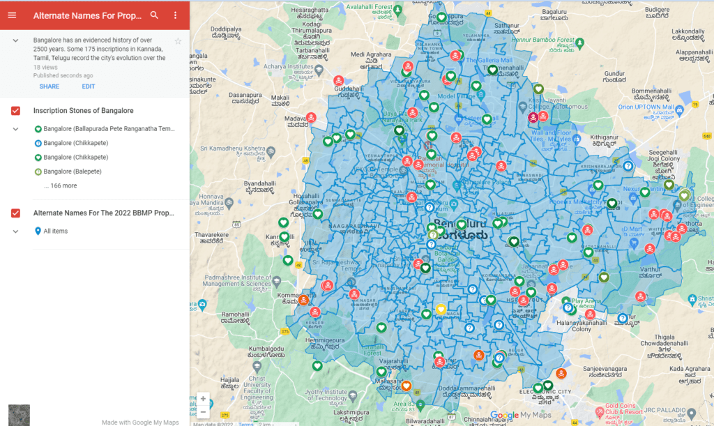
The coloured polygons are all wards, clicking on a ward brings information about the ward.
[Four history researchers of the Bengaluru Inscriptions 3D Digital Conservation Team worked to compile the list of alternate names shown in this map. They were greatly aided in their research thanks to the ward boundary KML files provided by Pratap Vardhan, Raj Bhagat Palaniswamy and the Citizen Matters, Bengaluru team.]
Excellent effort. History shouldn’t be erased according to the power needs of the day.