State Environment Impact Assessment Authority (SEIAA) has recommended environmental clearance for the first phase of the Bangalore Development Authority’s much-awaited Peripheral Ring Road project that will run from Tumkur Road to Hosur Road.
With this, the options that can help commuters avoid the city centre will increase, while real estate rates around the Peripheral Ring Road are expected to rise higher. This is meant to destress the Outer Ring Road, even as Bengaluru has been expanding without limits.
BDA’s Peripheral Ring Road will connect Tumkur Road to Hosur Road, via Bellary Road and Sarjapur Road.
Read this article published in 2011, to see the areas that the first phase of Peripheral Ring Road passes through. The recommendation for clearance can be seen on page 13 of 84th SEIAA meeting proceedings, dated November 18th 2014.
Except some areas in the suburbs, the alignment of PRR runs through the green belt; 60% of it runs through cropland, 17% via agriculture plantation and 16% runs in commercial plantation area.
What will the Peripheral Ring Road look like?
The idea of a Peripheral Ring Road for Bangalore has been projected even in the Comprehensive Development Plan – 1995 (CDP-1995). The length of the PRR was projected to be 116 kms, out of which the first phase was about 65 kms.
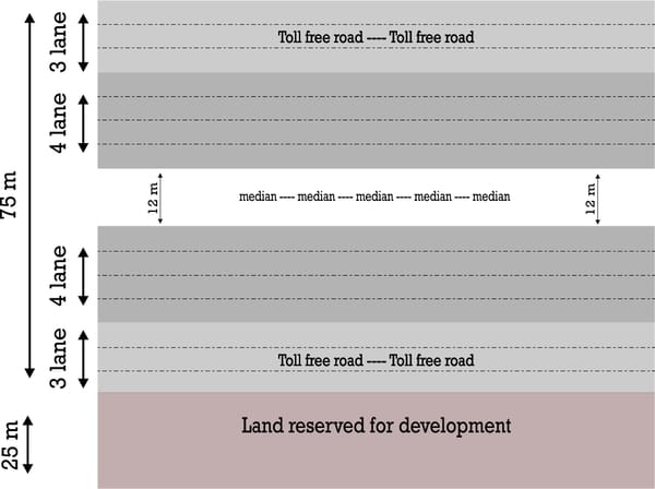
The PRR will have eight lanes on the main carriageway and three lanes on the toll-free service road on both sides.
Land acquisition will be done for a total of 1,920 acres for Phase I, for a width of 100 metres. Of this, 75 metres has been reserved for the main carriageway (eight lanes, where each lane is 3.5 metres wide), and the six toll-free lanes. The median will be 12 metres in with. If there arises a need to widen the road in the future, they will not widen it from the outer ends, but will take up space from the median area, is what BDA officials claim.
Another 25 metres running alongside the road has been kept aside for commercial development, as a joint venture between landowners and the BDA. This space will be used for amenities like water, electricity, and could include formation of sites anc commercial spaces.
The entire lenghth of the first phase is 65 km. There are efforts to integrate this with the NICE Road, whose alignment matches with the second phase of Peripheral Ring Road.
A visual representation of Peripheral Ring Road, as explained by BDA officials. Graphics: Shivakeshava
What does the environment clearance say?
According to the environmental clearance letter dated November 20th 2014, the first phase has provision for 69 box culverts, four minor bridges for passing Raja Kaluve and nalas. There will be 36 structures for passing national and state highways, and other roads.
The Environment Impact Assessment was done by the Hyderabad-based consultants, Ramky Enviro Engineers Ltd. The clearance letter states that there was a public hearing conducted at Bilishivale village in Bidarahalli Hobli (Bangalore East) by the Karnataka State Pollution Control Board.
The main conditions in the clearance letter are:
- There should be a three-lane toll-free service road on both sides, to enable villagers to commute.
- Adequate facility should be made for drainage so that the road is not flooded during anytime of the year.
- The drainage flow should be diverted to natural course, to avoid damage to agricultural land.
- There should be protective walls to prevent landslides in identified slopes.
- The project authorities should undertake social improvement measures, by providing training to local communities in monitoring environmental conditions along the road.
- There should be footpath on both sides for local communities.
- The project authority should undertake plantation along the road, as per the standards laid down by Indian Road Congress.
- There should be facility for rainwater harvesting along the road.
- No groundwater can be drawn for the project without permission. Tertiary treated water must be used.
- Underpasses should be provided in critical areas like villages.
- The concerns expressed in Public Hearing should be addressed.
- Any appeal against the clearance will lie with National Green Tribunal (NGT), and should be filed within 30 days of according the clearance (December 19th 2014).
Check the copy of the environment clearance at the end of this article.
When will the project actually start and finish?
Currently, according to BDA sources, the project is waiting for the Japan International Cooperation Agency (JICA) loan to come through. As soon as it comes, the project will start, say sources. If everything goes as BDA planned without any disputes, the construction will start by June-July 2015. However it does not seem so easy. There are many more miles to go before the actual road work starts.
Credit Risk and Infrastructure Solutions Ltd prepared a pre-feasibility report for PRR only in 2012. Now environmental clearance is in place. There will be a Social Impact Survey done, to estimate the impact of the project.
The Social Impact Survey for land acquisition has started on November 25th 2014 by Centre for Management and Social Research, Hyderabad. The survey will evaluate how many families will be impacted from the land acquisition may need rehabilitation, the impact of the road on environment and surroundings, and so on. This will complete in six months.
After that land will be acquired, and then the construction will start. If we recall the case of NICE road, the project was stalled for years because of disputes between landowners and the project company. There is every chance of same thing happening here, hence there can not be a timeline for PRR practically as of now.
What is the overall budget for the first phase?
The Detailed Project Report for the first phase projects a cost of Rs 9,600 crores (as on November 2014). Of this Rs 3,800 crores has been kept aside for construction and other miscellaneous expenses. Rs 5,800 crores has been allotted for land acquisition, but BDA predicts a possibility of this escalating, based on the new Land Acquisition Act.
At one point, the entire cost for the construction of PRR was projected to be Rs 550 crores, keeping in mind that the land cost of 8 lakh per acre. However, considering the cost of real estate has gone up multiple times, the land acquisition itself will cost way too much.
The PRR costs a huge Rs 58.46 crores per km. BDA officials justify this, as there will be additional infrastructure, such as bridges, dividers, underpasses etc. “Exact nature of the split will be presented in the DPR,” said a BDA official who did not want to be named.
Read: Is land acquisition really required for Peripheral Ring Road?
How is the project funded?
JICA is giving a loan of Rs 3,800 crores for construction expenses. Land acquisition expenses are not covered in the loan. One of the reasons that the BDA is relying on the JICA loan is because the rate of interest, pegged at 1.8% is considerably low.
BDA officials also stated that they have a plan of action to mobilise funds for the acquisition cost.
What is the land acquisition pattern?
BDA claims to be opting for a farmer-friendly land acquisition. Compensation for the land acquired will be done in the following three ways. Those selling land can choose any combination of the three ways, according to BDA.
- Money: An amount double the actual cost of land according to guidance value (The ratio is 1:4 in urban areas and 1:2 in rural areas). This is according to the Land Acquisition Act passed in Parliament, in December 2013.
- Transfer of Development Rights: A part of the land will be acquired, and transferable develpment rights will be accorded to the land owner for remaining part of the land.
- 60:40 ownership: On the 25 metre alongside the PRR, land will be developed free of cost (sites, commercial properties etc). BDA will retain 60% ownership of it and seller can keep 40%.
Who will benefit from first phase of PRR?
The first phase will cover 65 km. This will integrate many national and state highways around Bangalore -Tumkur Road, Bellary Road, Old Madras Road and Hosur Road.
This will help on two fronts—vehicles in the city, as well as those passing through the city. In a sense, it is also helpful for heavy vehicles that currently pass through the city, as they will not have to come into the city once the road is up. When this happens, the traffic in the city will also reduce, say BDA sources.
There is yet another effect on the city. There are many builders already acquiring land and promoting housing projects along the road. More housing projects on outskirts will hopefully help decongest the city to a certain extent.
Copy of environment clearance for the first phase of Peripheral Ring Road:
//
<a href=”http://s3.documentcloud.org/documents/1375488/state-level-environment-impact-assessment.pdf”>State Level Environment Impact Assessment Authority (PDF)</a> <br /> <a href=”http://s3.documentcloud.org/documents/1375488/state-level-environment-impact-assessment.txt”>State Level Environment Impact Assessment Authority (Text)</a>
Related Articles
PRR orphaned, even as builders use it for sales
Peripheral Ring Road: Out of 4500 Cr, is 3850 Cr for grabbing land?
No water for peripheral areas of Bangalore: Gaurav Gupta
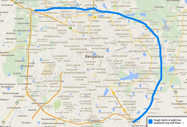
The above rough sketch picture of PRR passing regions is not accurate. Infact, the sketch is off by several kilo meters.
Here is the actual plan:
Use google maps and wiki maps to locate yourself.
Section 4.3 in the document:
http://www.iddkarnataka.gov.in/docs/41.peripheral.pdf
=======================
The stretch starts at Makali, adjacent to Tumkur road, moves north-east towards Thammenahalli and
Soladevanahalli, which are mainly agricultural areas, but with the exception of a mixed residential
area in Kuduregere and some protected land in some areas. The road intersects SH-39 at
Soladevanahalli, and some protected land in Kuduregere, Thammenahalli and Soladevanahalli.
Further up in Kempapura and Dodda Bylakere, the road goes along the borders of the green belt
area. After Dodda Bylakere, the road enters agricultural land in the green belt area. It goes through
the green belt area, passing through Mavallipura sewage treatment plant, before entering
Jarakabandekaval forest. It also intersects one primary urban road.
It then intersects Doddballapur road near BMS Institute of Technology,
around 3 km from the periphery of Yelahanka Satellite Town. Passing
through KEB layout, the road goes further east through residential areas,
intersecting Bellary road (NH 7) at Hosahalli.
The road then enters agricultural areas in Kogilu, and moves south along
residential and industrial areas in Agrahara, Thirumalenahalli, Bellahalli
and Doddagubbi. In Ramapura, the road again moves along the border of
green belt, separating agricultural and residential areas.
Further south-east, the road traverses residential areas in Hirandahalli,
intersects Old Madras Road (NH 4) near Sree Mahalakshmi Venkateswara School in Avalahalli. The
road passes through commercial areas in Avalahalli for about 2.5 kms, passes through residential
areas near Weavers Colony, and goes further down to intersect SH-35 near Govt Primary School in
Shigehalli. It then goes through Kumbena Agrahara towards Kadugodi.
In Kadugodi, the PRR intersects the railway line near Kadugodi Milk Federation Society. Most areas
around the alignment here are agricultural, with some mixed residential areas in between.
Moving down, it cuts across Channasandra main road in Channasandra, and curves west through the
residential areas in Nagondanahalli and Hagaduru. It then goes through green belt border in
Sorahunase and Varthur.
In Varthur, the road passes along mixed residential areas and Varthur lake, and goes further down
through agricultural areas. It intersects SH-35 near Kachamaranahalli. Around 3.5 kms further southwest,
it cuts across Sarjapur road in Sulikunte. All areas around this stretch are agricultural lands.
The road then curves south-west towards Gattihalli, Huskuru and Chikkanagamangala. It cuts across
both residential and agricultural land here. Going further south-west, the road moves along the
periphery of the industrial areas of Electronic City. It enters Electronic City and intersects with Hosur
Road (NH-7) near Suvidya College in Hebbagodi.
The PRR alignment as per BDA CDP 2015 can be found in the maps hosted in the Clearvalue Real-estate due-diligence website: http://clearvalue.in/BDA.html
Any links / plans available about the integration of existing NICE road and PRR-1 ? Is the official notification for the same available ?
which are the area cross through PRR passing region ??
what is the impact of the local people surrounding that PPR ??
please tell me on that
this road should not be reduced to 75 m at any cost , this metropol city is fast growing among other cities in the world . the vehs are day by day increasing . population also rapidly increasing . now it has its own recognition in the field of it bt,this road must be developed in the width of 100 mts as it was previously approved earlier. normally balgalore is called as the city of narrow roads.the area of the road region will get rapid development and the land owner also become rich in the remaining piece of land .but the compensation must be paid as the wish of farmers .
please develop the PRR in 100 mtrs so as to get rid from bangalore is the city of narrow roads.It is already been delay since 2007. The people of bangalore are facing lot of problems due to heavey traffic
Hi Will the survey no. 44 in kachamarana halli affect by Pheriperal ring road?