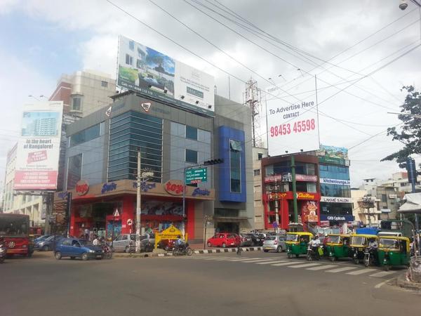
Sony World junction is a nightmare for vehicles during peak hour traffic. Pic: Ganga Madappa
Driving from Electronic City to reach Indiranagar in Bengaluru is a nightmare on most evenings. A precious 20 minutes will be lost while waiting for your turn to cross the Sony World junction signal. BBMP has acknowledged this traffic issue and plans to build a 2.4-km elevated flyover from Ejipura junction to Kendriya Sadan to improve the situation.
Unlike most solutions devised by officials and consultants, this is one of the few projects initiated following public demand.
In 2011, BBMP had planned to construct a signal-free corridor – Agara to Sirsi Circle, via Lalbagh road. After residents of Koramangala protested the need to have grade separators along this road and pointed out the negative aspects, the Agara to Sirsi Circle project was scrapped.
Citizens proposed that an elevated corridor be built on the 100 feet road, Koramangala, that runs from Ejipura junction to Hosur Road. Vijayan Menon, member of the Citizen Action Forum and a resident of Koramangala says, “We told BBMP that the signal-free corridor is required on the East West corridor and not on North – South corridor, as the entire traffic from Indiranagar to reach Hosur road cuts through Koramangala.”
Menon says that the original plan of BBMP was to build just one flyover at Sony World junction. “It was the hard work of a lot of citizens that this project (has been designed) in a proper way,” he adds. The 30-month project was sanctioned by the Central government under Jawaharlal Nehru National Urban Renewal Mission (JNNURM) in February 2014, just before the elections.
Heavy traffic throughout the day
Cars coming from Indiranagar and Old Airport Road zoom on the Inner Ring Road till Ejipura – a stretch of 2.5 km in a matter of 10 minutes. Then the commuters’ nightmare begins, as they have to pass three signals: Ejipura Signal, Sony World Junction and Kendriya Sadan (Koramangala Water Tank) Junction.
The story is same for the commuters travelling from Electronic city to Indira Nagar. The Detailed Project Report highlights that during peak hours, i.e morning 9 am to 10 am and evening 6 pm to 7 pm, all three junctions will have the traffic density of more than 8,000 to 11,000 Passenger Cars per Unit (PCU). Throughout the day, the traffic density remains at higher than 5,000 PCU, thus making the junction heavily trafficked.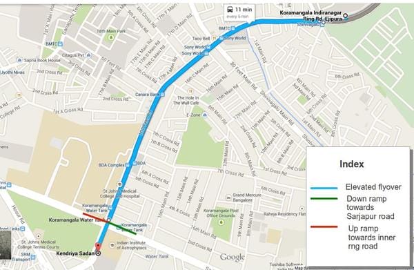
The route representation of the proposed elevated road from Sony World Junction to Kendriya Sadan.
Fly over the traffic
The 2.4-km long road will be bi-directional and will have four lanes. This will let the traffic cross the distance within 10 minutes. BBMP Executive Engineer of Roads and Infrastructure, Baswaraj Kabade says, “Once you hit the Inner Ring Road from Domlur, you needn’t stop anywhere till you reach the Kendriya Sadan.”
Nitin Seshadri, a resident of Koramangala and Member of Koramangala Task Force says, “There is no point in making small flyovers. It creates more traffic.” He continues, “The traffic heading towards Hosur road, Sarjapur road and Domlur, Indiranagar will fly atop without any traffic.”
According to the drawings, the flyover will have an exit-ramp for Sarjapur Road traffic on the left side towards Krupanidhi College, before Kendriya Sadan. On the right side, there will be an entry ramp for traffic going from St. John signal to Domlur, after St.Johns Hospital.
There is an entrance ramp planned on Sarjapur Road for traffic coming from the Hosur Road- Sarjapur Road junction to take the elevated road near St Johns Medical College. The Koramangala Task Force has proposed an alternative ramp location at 100-ft road itself so that traffic coming from Krupanidhi and Checkpost junction can take a turn into 100 ft road and then pick up the ramp.
Minimum land acquisition
The fate of every infrastructure project depends on how easily the land is acquired and utilities are shifted along with the number of trees that should be chopped. BBMP officials feel that the acquisition process will not be a problem as very little land is required, and whatever is required mostly belongs to the government.
“Only at places where the ramps go up and down (at Kendriya Sadan and at Ejipura junction) we will need land measuring approximately 2000 sq ft,” says an official. On both the ends of the flyover, the land belongs to the government. Hence Kabade believes that it won’t create much of a problem.
The DPR states that Rs. 61.8 crore will be required for land acquisition and utility shifting. The project is estimated to cost Rs.214 crore, including utility shifting. It is expected to complete in 30 months with six months for tender processing and the next 24 months for construction of the flyover.
286 trees to be cut
The DPR projects cutting of as many as 286 trees on this road. To compensate, BBMP has made provision for an afforestation plan. The DPR states, “It has been observed with management plans consisting of planting of trees in the ratio of 1:2, proactive afforestation for green cover and development of green ribbon in and around the project area, it will be abundantly compensating the green cover.”
The tender for the project is being processed, and the project is expected to be approved within next three months.
Related Articles
Citizens victory: High Court stays Agara-Sirsi flyover
ORR flyover work by BDA chokes traffic
BDA flyover path hijacked by Metro
BBMP plans to merge Silk Board elevated road with Metro line
Okalipuram 8-lane corridor project to start in December
2011? 2016?
I don’t think Indian engineers are capable of designing and building a proper bridge/overpass/flyover [OK. Prove me wrong]. We are already importing cars, why not a bridge? Lets bring the best engineers in world and the best materials and the best technology. All the so called ‘flyovers’ are a disgrace to engineering. We can build a show-piece that the rest of the country can use as a yardstick to build flyovers. And the timeframe – years??? How about months? Use rapid construction methods and Karnataka can even charge (heh, heh, the highest fee) to provide training to engineers from other states.
Yet another nonsensical plan! If you need to help traffic congestion, please stop the usage of private vehicles, especially cars. Do not encourage such criminal ideas.
Truly Elevated over hearing this news. But, apprehensive, and do not think it will come up. simple solution to de-congest and save hard earned money of tax payers is –
a) BMTC introduce free-ride of volvo or subsidized tariff say Rs 5, 10, and 15 upto from Madivala junction connecting Hosur road to Old Madras Road (indiranagar) with frequent bidirectional, so that most of the four wheelers (heading Embassy IT park and 100 ft business shops) will automatically take advantage.
Of late the traffic congestion/vehicles clogging has become order of the day during peak hours on INNER RING ROAD between Domlur –Airport Road Flyover to Koramangala (upto Oasis Centre/Tacho Bell/Sony world). The length of this Inner Ring Road stretch from Domlur Flyover to The Koramangala Inner Ring Road is approx. 4.0 kms on each side and 8.0 kms on round about. The average time required to get from one end of the road to the other end on this stretch during peak hour is about 30 to 45 minutes as against 5 to 10 minutes. This stretch of Inner Ring road connects vital extensions like Indiranagar, Old Madras Road, Kasturi Nagar, Kalyan Nagar, Koramangala, Madiwala, BTM Layout, Hosur Road, Bannerghatta Road, Jayanagar, Wilson Garden, Ulsoor, Kodihalli, Marathahhali and surving as direct link to International Airport in bound and outbound commuters. On an average the traffic flow on this INNER RING ROAD stretch of 4.00 + 4 kms exceeds 10,000 vehicles per hour during peak hours and 5,000 vehicles during non- peak hours. However, the stretch is contributing 24 hours of traffic volume without break with ever increasing day by day.
Thanks to the Traffic Management team and Police personnel posted on this stretch to ease the congestion during peak hours. But, the result has not brought enough relief to commuters satisfaction. The long wait and choking traffic has made residents of Domlur layout, ISRO Residents, Natasha Golf View residents, Amarjyothi Layout residents, on both stretch of this road to has exposed to unbearable noise pollution and air pollution causing health hazards to occupants. Hours together -choking traffic and round about travel on this stretch of inner ring road is making vehicle owners draining precious fuel (petrol and diesel) to an alarming measures and wastage of our precious foreign exchange to the nation.
If one can analyse the reason for this choking traffic on this stretch of inner ring road, it is evident that the stretch of this inner ring road is not properly managed for traffic flow with intermittent diversions at appropriate places as required from time to time since its inception.
This stretch of Inner Ring Road came into existence during 2004 and 2005 to ease the traffic choking on old airport road between ASC centre to Domlur and Indiranagar 100ft Road. However, there were no residential or commercial activities built up on this stretch of inner ring road until 2009. Thereafter with emergence of Maruthi Infotech Park, Challaghatta Infotech Park and Embassy Infotech Park with 100 to 200 units of commercial office spaces of IT and BT activities, commercial office spaces, hotels, residential houses on Amarjyothi Layout, diamond District and Multistoried residential apartments on this inner ring road boomed to hectic vehicular traffic of inflow and out flow within the layout. Added to this, the shifting of domestic HAL airport to International Airport this stretch of road has become a nodal and focal route to commuters all over the Bangalore to pass through this stretch of Inner Ring Road 24 hours a day.
At present this stretch of DOMLUR – KORAMANGALA INNER RING ROAD of 4 KMS of both roads has only one OPENING with U TURN after Embassy Tech Park for residents of this locality as well as floating traffic causing choking point at U TURN point on both stretch of the road. As a result of this more than 2000 vehicular traffic that congregates from flyover, 100 ft ring road, koramangala, ejipura, sarjapura intends to get inside the CHALLAGHATTA, MARUTI TECHNO PARK AND EMBASSY TECH PARK hovering around this inner ring road to and fro or round about motion to get into their respective business centre. As a result, the ongoing traffic flow on this stretch of road gets into bottle neck causing hours to-gether traffic jam.
In order to bring choking traffic level on this stretch of Inner Ring road, the following suggestions may please be “tried and tested” if not result oriented, reverse back to square number one situation.
1. ERECTION OF TRAFFIC SIGNAL LIGHT POSTS OR
CUTTING OF ROAD MEDIAN AT TWO OR THREE STRETCHES NEAR
a) Maruti Infotech Centre (DELL) or EMBASSY TECH PARK
b) HERO HONDA SHOWROOM/TVS TRISTAR
c) Provide U turn facility near Hero Honda showroom for traffic
Flow from domlur to koramangala –
This will help residents of ISRO, NATASHA GOLF VIEW, Amarjyothi Layout
Challagahatta residents and other business center occupants go towards
Domlur or Indiranagar and airport road instead of round about route.
d) Provide RIGHT TURN and U turn facility near Embassy Tech Park
This will help intended vehicular traffic (around 1000 per hour) approaching from Koramangala /Ejipura road would compulsorily take right or u turn for their respective business centres instead of making round about below the flyover road.
e) At present if one has to take U TURN from entrance of Tacho Bell/Koramangal Signal point road stretch the U Turn at Ejipura is not permitted as well as at Cutting Point on inner Ring road, One has to travel upto 3.5 kms on this stretch – go upto domlur flyover and come back towards opposite side of the road – does this has any meaning ????? Providing U turn and Right Turn at (a) and (b) points will ease this problem.
f) Provide ‘SPEED BREAKERS’ near ISRO RESIDENT GATE 1 on onward road from Domlur flyover to Koramangala and near ADARSH REGENT – so that vehicles speeding both sides would slow down to take care of pedestrians – school children, senior citizens, aged people and ailing people crossing the road stretch from one end to the other side.
g) Reduce the existing width below the flyover near domlur flyover to ISRO gate and from existing U SHAPE to V SHAPE, so that more space is available for bus, maxicabs and other vehicles passing below the flyover to take U TURN from Koramangala – Ejipura stretch. One more pedestrian path can be created below this flyover
h) Vacate the existing petty shop vendor, tender coconut vendor, and a beggar from airport road to koramangala road stretch and make the pavement more easier for pedestrians usage. Daily around 1000 to 2000 IT / BT personnel walk over this stretch towards Maruti Infotech and other companies . Make over of this stretch will immensely help the pedestrians to a great extent.
i) Re orient the road end and flyover space utilization and erect a bus stop below the domlur flyover on both sides of the road, so that traffic flow are regulated and immensely help the commuters seeking change of
j) Recently the CPWD at domlur has started demolishing its age old residential buildings numbering 6 blocks. The venue is Domlur Flyover right side, Service road, 1st Main Road, 14th Cross, Domlur Layout, Bangalore 560071.They have not taken up any precautionary measures to combat the dust and dust particles that is being discharged due to demolition. The adjacent residential houses and ISRO residential housing quarters inmates are the most affected residents due to this demolition The demolition process may go over more than 5 to 10 months as the progress of work is being carried out. Repeated representation and appeals to the government agencies have not resulted in any measures. They say having permitted by pollution board to demolish the building at their own fancy.The dust eminated from the demolition scattering to great heights and distance causing triggering asthama, cold, nausea, breathlessness, choking and other skin related issues to young kids, adults and aged inmates of the locality. The microfine dust settles down through residences of 7and 8th floors house which is almost half a km from demolition through out the night.
As of now this DOMLUR road FLYOVER junction is polluted with 24 hours of NOISE pollution, traffic pollution, morning, evening and night smoke pollution caused by lighting waste and dried leaves by BBMP personnel. The autorikshaws without mufflers causing heavy smoke and sound pollution through out the night as there areno checks on these vehicles. The BMTC age old buses that pass through under the flyover and above thelyover makes thud and thud noises with their strange sounds and smoke emissions. You can also measure the decibel of soundand smoke pollution caused through out 24 hours by installing a device which will be the highest in Bangalore city and suggest measures to bring down the same.
You are requested to kindly inspect the spot and advise the concerned to adopt measures to control the dust and rubbles falling due to demolition and help the residents to breathe easy for some time. With me there are other hundreds of residents joining me to bring this matter to your notice as our appeal.
The measures indicated above will definitely bring relief to residents, pedestrians, commuters, and ease the present congested, choking traffic movement to more meaningful on this stretch KORAMANGALA – DOMLUR INNER RING ROAD, which is required at present scenario in view of the development that has taken place in the locality.
With regards
Thanking you,
NAGARAJA BABU M S
Resident of Domlur since 1996
The presence of an elevated road will only shift the delays to the next signals. In effect there is no logic to this project. In addition, and more importantly, the trees that line the road near St John’s and BDA complex area cannot be replaced! They are large and magnificent, and there is no place such planting activity can be taken up. BBMP has already done a large disservice by cutting trees on Sarjapur Road without reason, and this should not be allowed to happen. The taxpayers money is being wasted without thought, and without accountability.
Yes we need fly overs – it can avoid crossing unwanted spots and crossings. But I feel we can manage bangalore traffic more efficiently if the following things are done (but its tough)..rules for autos, and all center vehicles, rules for BMtc buses, rules for Cyclist, rules for pedestrians – when i said rules – – say wandering autos who hunt for Bakara or desperate customers- they block the bangalore traffic. callcenter cabs have their own stops for pick up and drops which are not appropriate, some just after the signal. BMtC buses stops at the center of the road.Above all The new breed of north Indians on cycles think they need not follow any rule as they are transparent – police is least bothered because they do not have number plates and cannot collect any fine…lol (because today we work only for money, unless collection is there we do not mind) Then the high tech intellectuals with Hitech phones and gadgets, in their ear who walk across the street- without minding any laws or rules. Start teaching road disciple at school ” Look to the right, look to the left before crossing” God Save Bangalore.
I think this is not a bad idea to solve some issues .. but definitely it needs more entry and exit points and as follows .
1. Entry near sony world.
2. Exit near kamat so that some traffic gets diverted to krupanidhi college via koramangala
Good idea…hope they have entries and exits planned across the lenght of this express flyover…
THE Best way to avoid traffic at koramangala is to divert all sarjapur road traffic vehicles from ejipura itself, why to take all the traffic till krupanidhi college
the moment vehicles hit ejipura singnal, the vehicles can take left from ejipura and the road reaches agara lake. this saves lot of time and eaze the traffic at koramangala.
the srinivagilu road ( not maintained for many years ) can be used now to divert traffice to sarjapur road… why dont you think about this suggestion.
lets work for a better BANGALORE