Ajit Prakash drives from Iblur junction to his office in Koramangala everyday. The three kilometre drive generally takes him about 20 minutes. But on 12th February, Prakash took nearly two hours to get to his office; thanks to a traffic jam that extended from beyond Sarjapur Road all the way up to Agara junction and further. Manjunath R, also on his way to Koramangala, was caught in the jam for almost two and a half hours.
B Lokesh, Assistant Commissioner of Police (Traffic), Adugodi, says the reason for the hold up was because of incomplete work by the Bangalore Development Authority (BDA). Lokesh explains that the BDA had commenced work on removing the median overnight but had not asphalted the place after digging it up. “The problem was there only on that day. Now everything is fine. We have increased manpower at the Agara junction,” says Lokesh. The BDA though, gives a different reason for the traffic pileup. “A truck broke down. I wasn’t there at the site that time,” says Prem Kumar, Assistant Executive Engineer, BDA.

B Lokesh, ACP Traffic Adugodi Sub-division (Pic: Vaishnavi Vittal)
As work gets underway on the Agara-Iblur flyover project, commuters and residents are facing the heat. Though the jam on 12th February was a one-off case, the situation isn’t very bright on other days. Prakash says the situation will only get worse as work progresses. “I had to take a roundabout route on the day of the jam. There is no coordination between the cops at successive signals,” says Prakash. And Manjunath feels that a signal is required at Agara junction to control traffic.
Manning the traffic at this junction are an Assistant Sub Inspector (ASI), a Sub Inspector (SI) and three constables. At Iblur junction, there are two ASIs apart from the constables. For these traffic policemen on the field, it’s a gruelling task. “On some days we come here at 6.30 AM and go back at 10 PM. It’s a strenuous job. We don’t even have time to eat. Nobody says thank you to us. It’s a thankless job,” says B H Munikrishnappa, Senior Traffic Inspector. Munikrishnappa feels that motorists need to be responsible. “Even if there is a traffic signal, no one follows it. Animals are more disciplined,” is his opinion.
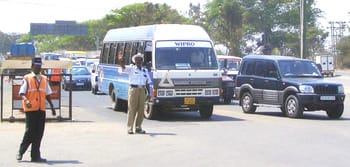
Traffic policemen and warden manning the junction (pic:VV)
Solomon Thomas, a resident of 27th Main, HSR Layout, says the mistakes happen during the execution of the project. “Poor traffic management, improper road medians, construction work and movement of construction equipment and supplies is done mostly during the day time which causes a bottle neck and loss of time for commuters,” says Thomas. He adds that with over 200 cars travelling through that stretch every 10 minutes, the amount of fuel wasted due to the jams at these junctions is really high.
Even as commuters complain about the roadblocks on this stretch, most do not know what the exact plan and design of the project is. Citizen Matters spoke to BDA officials and experts to get a better idea.
Details of the flyovers
There are two parts to this project – Iblur and Agara. The Iblur project includes a right carriageway (flyover) which is 11 meters wide, left carriageway (grade level road) which is 13 meters wide, two Bus Rapid Transit Systems (BRTS) lanes, each measuring 3.5 meters in width and a service road which is 6 meters wide. The length of this entire stretch is 642 meters. One bus bay is indicated in the drawing, which is 2.5 meters wide. Vijay Narnampatti, architect and member of Hasiru Usiru, says that a circle at the junction that leads to Sarjapur might be a good idea. “A large circle at this junction will help keep the traffic moving. An underpass like the one at Mekhri Circle will also help. This will avoid the need for a signal at this junction,” he explains.
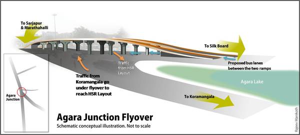
Visualisation of Agara flyover based on information provided by BBMP (Illustration: Rajeev Manikoth) …Click here to view full picture.
The Agara project consists of two flyovers. While the width of one measures 3.5 meters, the other is 5.5 meters. In between the flyovers are the bus lanes which are 0.6 meters wide. One of the bus lanes will be directed towards Iblur and the other towards Silk Board. On either extreme are service roads, each measuring 0.6 meters in width. The entire length of this flyover is about 900 meters. Specifications of pavements on the service road have not been mentioned though they do figure in the drawings. Also, no bus stop has been indicated in this drawing as in the Iblur project. According to Prem Kumar, Assistant Executive Engineer, BDA , the space below the flyovers will be utilised for landscaping. Narnampatti points out that there are no markings for a pedestrian crossing in both the plans.
Comparing the two drawings (general alignment), the Agara drawing does not mention any contractor while the Iblur one mentions the contractor to be Nagarjuna Construction Co. Limited. There is also a difference in the terms used for bus lanes. While the Agara plan refers to them as bus lanes, the same is called BRTS lane in the Iblur plan. Also, the Agara junction has two flyovers because of the number of cross roads at the junction, whereas there is only one flyover at Iblur junction because there aren’t as many cross roads.
Why the flyover?
Speaking about the need for a flyover at these junctions, Prof M N Sreehari, advisor to Government of Karnataka for Traffic, Transport and Infrastructure, says it will help in seamless traffic on Outer Ring Road (Prof Sreehari is also the CEO of Consortia of Infrastructure Engineers). While an underpass is better because of its stability and strength, Sreehari, who is also an expert member of Agenda for Bangalore Infrastructure Development (ABIDe), says it isn’t advisable when there is a water body nearby (in this case, the Agara lake). While Sreehari says consulting a traffic expert for projects like these would be a good idea, he says asking the public for suggestions would only cause confusion.
ABIDe recommendations mention that Outer Ring Road (ORR) be made signal free and service roads along ORR, wherever available, be completed in all respects. It also says that all big 10 arterial roads be converted into six-lane, signal-free and junction-free pathways between ORR and the next major town (in this case, Sarjapur), with median provision for MRTS later. The report says that priority (not dedicated) bus lanes should be marked all along ORR for faster movement/promotion of public transport, and bus bays/shelters and footpaths to be made mandatory.
Prem Kumar says that the BRTS is a project of the BMTC and funded by them too. Sreehari explains that the idea of including BRTS is to reduce the usage of cars. “The exact plan for the BRTS will be done once the structure comes up. Sometimes there may be congestion on the other roads and the BRTS lane will be free, then we will have to make use of it,” says Sreehari. R K Misra, co-author of the Roads, Traffic Management & Transportation report and member of ABIDe says that he has asked the BDA to rework the BRTS design and planning. “As a policy, we want them to have these lanes. We are looking at the bus lane being shifted because if the car wants to go straight and the bus wants to go left, as per the present design there will be a clash. So we are changing that.” He refused to divulge further details until the plans are finalised.
Progress of work
As per the Madiwala traffic police at least 2000 two-wheelers, 2250 Light Motor Vehicles (LMV), 400 buses and 200 trucks pass through this stretch every hour. What seems to be of most concern to residents and commuters is the progress of work and traffic management. Prem Kumar says the maximum disturbance is likely to be caused during the launching of the girders which will take place in about two months’ time. Work on the service roads will begin after casting is complete and they will be ready for use in a month’s time, he adds. Sreehari says that alternate routes need to be identified and strengthened before construction.
In order to ease traffic, the traffic police have requested the BDA to reduce the width of the circle at Agara junction. A signal will be added at the junction once the flyover is constructed, says T Venkatesh, Circle Inspector, Madiwala Traffic Police Station. Even as the traffic police say they are pressurising the BDA to speed up work, ACP Lokesh says, “They (BDA) aren’t bothered about traffic. They want to use maximum space. They haven’t given us any plan either. We only know that there are going to be two flyovers. We will insist for the plan.”
Lokesh says that the BDA should only use space that is required. He says the traffic police, on their part, have increased manpower at the junction, monitoring these junctions regularly, with senior officials going on rounds.
What citizens are most concerned about is the management of traffic. Prakash says what is required is traffic management and not construction management. On suggesting that the road from Agara junction leading to Koramangala and the road from Agara junction towards Silk Board be made one ways, in opposite directions, Lokesh says he would give it serious thought and discuss it with his subordinates. Misra says that residents of nearby areas can forward their suggestions to the Additional Commissioner of Police (Traffic), Praveen Sood.
But will this project be ready on time? “A project like this shouldn’t take more than a year. The BDA must work day and night,” says Prof Sreehari. But ACP Lokesh says this project will take at least a year and a half to be completed. Prem Kumar, on the other hand, is positive and says the project will be ready as per schedule in April 2010. ⊕
Really informative piece. Must thank you for throwing some light on this ‘mystery’ 🙂
I know it’s like asking for too much, but could you please put up a drawing for the Iblur project as well? I am find it hard to visualize how the bus transit system is going to play in Iblur.
A rough 2d sketch would suffice.
Thank you! This information was much required. I commute to my office at outer ring road everyday and have been experiencing the various woes due to these two flyovers. At least now I have a clearer picture of what to expect in the coming months!